Vík: Iceland's southernmost village and black beach base
Vík as an overnight South Coast base: Reynisfjara black beach, Katla ice caves, Sólheimajökull glacier hikes, and the DC-3 plane wreck. Costs included.
Reykjavik: South Coast and Katla Ice Cave Small Group Tour
Duration: 10 hours
Quick facts
- Distance from Reykjavik
- ~187 km, ~2.5h on Route 1
- Population
- ~500 permanent residents
- Reynisfjara
- 8 km west of Vík, free parking
- Nearest petrol station
- N1 in Vík village center
- Accommodation
- ~20,000-40,000 ISK/night (~€136-272) for doubles
Vík: small town, large strategic value
Vík í Mýrdal (population ~500) is Iceland’s southernmost village, sitting at the point where Route 1 passes closest to the Atlantic and the Mýrdalsjökull glacier looms directly behind the town. On its own, Vík has limited attractions: a supermarket, a petrol station, a few hotels and guesthouses, and a church on a headland that appears in every South Coast photograph. What makes it worth planning around is its position — within 30 minutes of Reynisfjara black beach, 30 minutes of Sólheimajökull glacier, and 20 minutes of the Katla ice cave trailhead.
Day-trippers from Reykjavik reach Vík after 2.5 hours of driving, spend 1-2 hours, and turn around. Overnight visitors get Reynisfjara at 07:00 before the tour buses arrive, a morning glacier hike, and time to explore the coast at their own pace. The difference in experience is substantial.
| Where | ~187 km southeast of Reykjavik, southernmost village in Iceland |
| Time needed | Overnight recommended; day trip possible but rushed |
| Cost | Doubles around 20,000-40,000 ISK/night |
| Getting there | ~2.5h self-drive or coach on Route 1 |
| Best time | Year-round; winter for ice caves, summer for midnight sun |
Reykjavik: South Coast and Katla Ice Cave Small Group Tour
Day trip versus overnight: the honest comparison
| Day trip from Reykjavik | Overnight in Vík | |
|---|---|---|
| Reynisfjara timing | Mid-morning to afternoon, with crowds | 07:00-08:00, often near-empty |
| Total driving | 5 hours round trip | Split across two shorter drives |
| Pace | Rushed, 1-2 hours on the ground | Relaxed, a full morning and evening |
| Katla ice cave (winter) | Difficult to combine with the drive | Departs from Vík itself, no extra transit |
| Cost | Cheaper — no accommodation | Adds one night’s lodging |
Reynisfjara without the crowds
Reynisfjara is 8 km west of Vík on a signposted turnoff from Route 1. The beach’s composition — fine black volcanic sand, hexagonal basalt columns, the Hálsanef cave, and the Reynisdrangar sea stacks — makes it consistently the most photographed natural feature on the South Coast.
At 10:00 on a July day, the parking area holds 50-80 cars and tour buses. At 07:30, you may have the beach to yourself. This is the practical advantage of sleeping in Vík rather than commuting from Reykjavik.
The wave danger is real and permanent. The sneaker waves that sweep the beach without warning have killed people who stood at the waterline even on apparently calm days. The rule is simple: do not go near the water. The basalt columns, cave, and stacks are all photographable from well above the waterline.
The Reynisfjara name comes from the Reynisfjall headland (340 m) that forms the eastern boundary of the beach. A trail climbs to the headland summit — 1.5-2 hours return from the beach parking area, genuinely steep, rewarding views over the coastline and Vík bay.
Víkurkirkja: the photograph and the reality
The white church on the headland above Vík (Víkurkirkja) is photographed from Route 1 looking south, with the Reynisdrangar stacks in the background and often under dramatic clouds. The church is a working Lutheran congregation built in 1934. It is accessible up a marked path from the village; the walk takes 10-15 minutes. The view from the churchyard over the town and bay is worth the climb independent of the photography.
Vík’s older buildings and the harbor area north of the church give a sense of the original fishing village that preceded the tourism infrastructure. Nothing is preserved as a tourist site — it is simply functional.
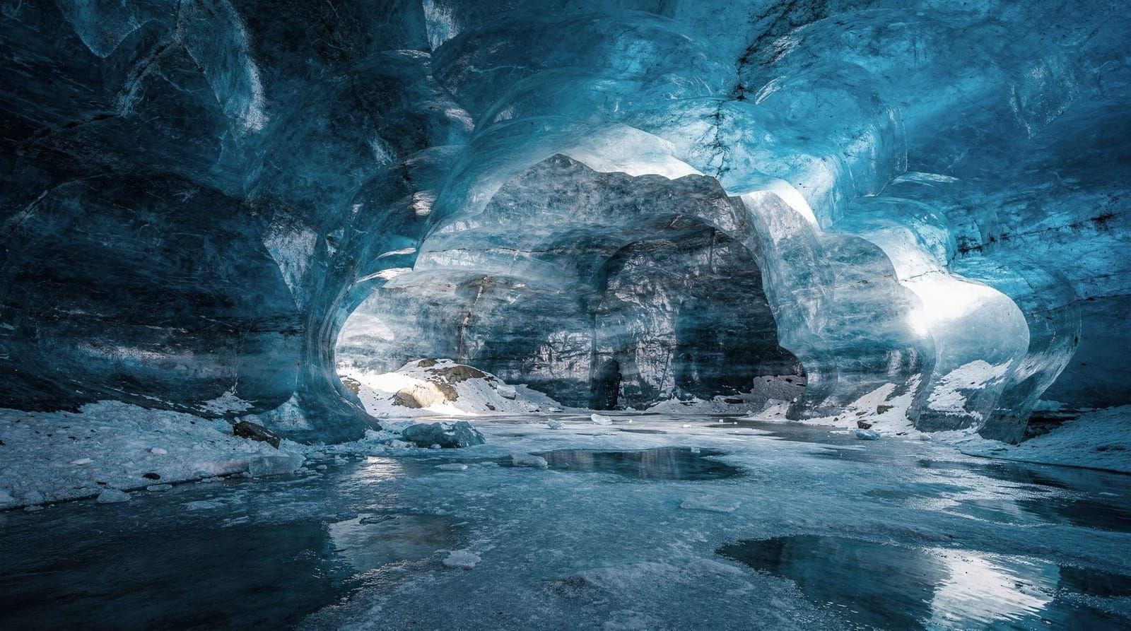
Katla ice cave access (October through March)
Katla is a subglacial volcano beneath Mýrdalsjökull, directly above Vík, that last erupted significantly in 1918. The volcano is monitored continuously for signs of eruption; several false alarms since 2010 have triggered emergency evacuations. This is not a reason to avoid the area — just context for the evacuation alarm poles you will see on the main roads around Vík.
The Katla ice cave tours access natural ice formations within the Mýrdalsjökull glacier above the volcano. They require a super jeep to cross the black sand lava fields and a licensed guide to reach and enter the cave safely. The cave interior exposes black ash layers from Katla’s 1918 eruption compressed between ice walls — stratigraphy you can literally touch.
Book a Katla ice cave and super jeep tour from Vík for the most direct access — the tour departs from Vík itself, saving the driving time if you are already based here. Season is October through March; February and March tend to have the most stable conditions.
Sólheimajökull: the glacier at walking distance
Sólheimajökull is 30 km west of Vík via Route 1. The parking area is signposted; the walk to the glacier terminus is 15-20 minutes on gravel. Without a guide you reach the edge; with a guide you get crampons and access to the ice surface.
Book a guided glacier hike on Sólheimajökull from Vík for the full experience. Guided tours depart from both the Sólheimajökull parking area (if you have a car) and from Reykjavik (longer driving day). From Vík, the logistics are simpler: drive 30 minutes, join the guide, hike 2-3 hours, drive back.
The glacier has retreated measurably every year since records began. The 1987 terminal position is marked on a sign at the parking area; comparing that position to the current ice face — several hundred meters further back — is a concrete illustration of the change.
The DC-3 plane wreck
The wrecked US Navy Douglas C-47 Skytrain (military designation DC-3) that made an emergency landing on Sólheimasandur in 1973 sits on the black sand plain 10 km west of Vík, accessed by a 4 km walk across the sand from a parking area on Route 1. The wreck is rusted into abstract shapes, partially collapsed, and fully photogenic.
The walk each way is flat but exposed to wind from any direction — an umbrella will turn inside out. Allow 2-3 hours return. Driving the flat sand to reach the wreck is prohibited and has been since 2017 due to the damage vehicles caused. Some quad bike tour operators access the general area legally from their own private roads; the pedestrian approach from the Route 1 parking area is the standard access for most visitors.
Þórsmörk: the highland valley from Vík
Þórsmörk (Forests of Thor) is a highland valley 30 km north of Vík across the Þórsmörk highland road (accessible by super jeep only — the rivers Krossá and Markarfljót are unbridged). It forms the southern terminus of the Laugavegur trail from Landmannalaugar and is a dramatic landscape of birch forest, volcanic ridges, and glacier-carved valleys.
Day trips to Þórsmörk from Vík or Reykjavik are available via super jeep operators — the crossing is not safe in a standard 4x4. The drive from Vík takes 30-45 minutes to the parking area. Summer season (June to September) only.
Eating in Vík
Options are limited compared to Reykjavik but adequate for an overnight stop. Suður-Vík serves reliable Icelandic comfort food (lamb, fish, burgers) in a converted house on the hillside above the village, with the best view in town from its dining room. Halldórskaffi, in the same building as an old general store, does pizza and simple mains at fair prices. The N1 petrol station has a basic grill counter for a quick, cheap meal if you are pressed for time. Book ahead in July and August — the town’s few restaurants fill with the same overnight crowd competing for tables.
Accommodation in Vík
Vík has approximately 15-20 accommodation options from basic guesthouses to a handful of small hotels. Key properties:
Hótel Vík í Mýrdal: the most centrally located hotel, standard Icelandic hotel quality, doubles from 30,000-40,000 ISK in summer (€204-272). Advance booking essential from June through August.
Guesthouses and self-catering: several smaller guesthouses within walking distance of the supermarket. Expect 20,000-28,000 ISK (~€136-190) for a double room with breakfast.
Camping: the Vík campsite is open June through August, basic facilities, ~3,000-4,000 ISK per person per night.
Book well in advance for July and August — Vík’s accommodation fills fast. For the full South Coast itinerary including overnight options and all stops between Reykjavik and Jökulsárlón, see the South Coast complete guide. The Iceland 7-day from Reykjavik itinerary shows how Vík fits into a longer route. For winter planning, see Iceland winter vs summer guide.
Top experiences
Bookable activities with verified prices and instant confirmation on GetYourGuide.