South Coast Iceland: waterfalls, glaciers, and black sand beaches
Iceland South Coast guide: Seljalandsfoss, Skógafoss, Reynisfjara black beach, and glacier hikes. Real costs in ISK, drive times, tour options.
Reykjavík: South Coast Waterfalls, Black Sand & Glacier Tour
Quick facts
- Distance from Reykjavik
- ~170 km to Vík, ~2.5h on Route 1
- Seljalandsfoss parking
- 900 ISK (~€6)
- Skógafoss parking
- Free
- Reynisfjara parking
- Free
- Glacier hike cost
- ~12,000-18,000 ISK per person (~€82-123)
Iceland’s most dramatic 200-km corridor
The South Coast route along Route 1 (the Ring Road) from Reykjavik to Vík — and beyond to Jökulsárlón if you push it — delivers more concentrated landscape drama per kilometer than anywhere else in Iceland accessible from a standard rental car. Waterfalls walk-behind, glaciers accessible on foot, Europe’s largest black sand beach, and basalt sea stacks: it is a legitimately astonishing stretch of road even by Icelandic standards.
One day gets you Seljalandsfoss, Skógafoss, a glacier visit, and Reynisfjara. Two days lets you continue to Jökulsárlón and return properly. Three days is the pace to actually enjoy it.
| Where | Route 1 from Reykjavik to Vík, ~170 km |
| Time needed | 1 day for the highlights; 2-3 days done properly |
| Cost | Parking 0-900 ISK per stop; glacier hikes 12,000-18,000 ISK |
| Getting there | Self-drive on paved Route 1, or a guided coach tour |
| Best time | Year-round; ice caves added Oct-Mar |
Reykjavík: South Coast Waterfalls, Black Sand & Glacier Tour
How much of the coast to see, by trip length
| Days | Realistic itinerary |
|---|---|
| 1 day | Seljalandsfoss, Skógafoss, a glacier hike or viewpoint, Reynisfjara, back to Reykjavik late |
| 2 days | Day 1 as above with overnight in Vík; day 2 adds Fjaðrárgljúfur canyon and/or a Katla ice cave, or push on to Jökulsárlón |
| 3 days | Spread the same stops with unhurried mornings at each, add Fjaðrárgljúfur, and overnight near Jökulsárlón before returning |
Seljalandsfoss
At 60 meters high, Seljalandsfoss is not Iceland’s tallest waterfall but it is the one with a path that takes you behind the curtain of falling water. The walkthrough is slippery, constantly damp, and genuinely exhilarating — waterproofs essential, phone cameras survive if protected. In winter, ice formations build on the surrounding cliffs; the behind-the-falls path closes when icy (October through March approximately).
A short walk further west along the cliff face is Gljúfrabúi, a hidden waterfall tucked inside a narrow gorge. Few visitors bother; most miss it. Wade 20 cm of stream water through the gorge entrance and you find yourself inside a thundering chamber. It is worth the wet boots.
Parking: 900 ISK (~€6). Distance from Reykjavik: 112 km on Route 1, about 1.5 hours.
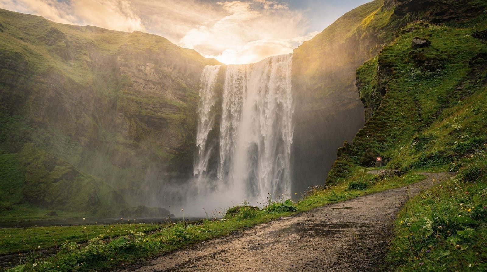
Skógafoss
Skógafoss drops a sheer 62 meters across a 25-meter-wide face. Unlike Seljalandsfoss, you cannot get behind it — but the power and scale from the base are considerable. A staircase on the east side climbs 370 steps to the top of the falls, where a river trail continues up into the highlands toward Fimmvörðuháls pass and ultimately Þórsmörk. The first kilometer of this trail along the Skógar river, past a succession of small falls, is worth 30-45 minutes.
Rainbow conditions at Skógafoss are reliable on sunny mornings when spray catches the low sun — the falls face almost due south. The folklore attached to Skógafoss involves a Viking chest of gold hidden behind the falls; it is retold on every tour bus and in every guidebook.
Distance from Seljalandsfoss: 30 km, about 25 minutes. Parking: free.
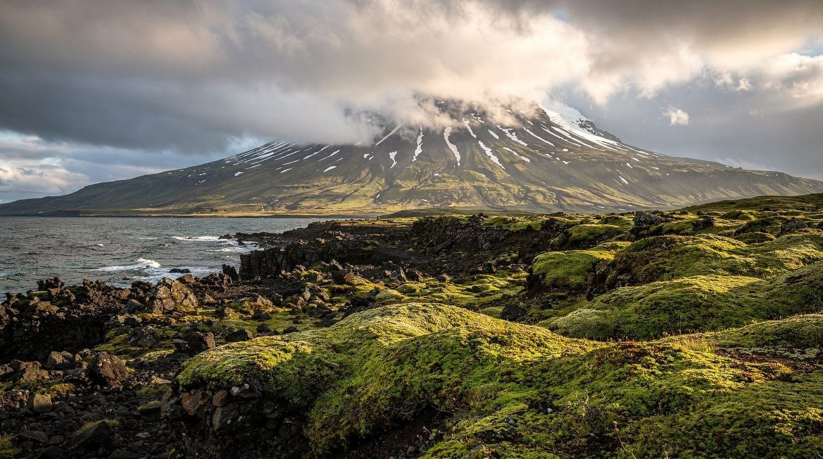
Sólheimajökull glacier
Sólheimajökull is a finger glacier of Mýrdalsjökull (which caps the Katla volcano) and is the easiest glacier to access on the South Coast. The parking area is signposted from Route 1 between Skógafoss and Vík; the walk to the glacier snout is 15-20 minutes on gravel.
Without a guide, you stop at the glacier’s edge. With a guide, you get crampons, ice axes, a helmet, and 2-3 hours on the glacier itself — crevasses, meltwater channels, and blue-black ash layers from Eyjafjallajökull’s 2010 eruption. Guided hikes run year-round with different character: blue ice in winter, meltwater channels in summer. Cost: 12,000-18,000 ISK (~€82-123) per person depending on group size and operator.
Book a guided glacier hike on Sólheimajökull directly from Vík or as a full-day tour from Reykjavik. For more detail on what to bring and glacier conditions, see our glacier hikes and ice caves guide.
The glacier has retreated significantly over the past 30 years — satellite imagery comparisons at the parking area show the recession clearly. What you see today is measurably smaller than what visitors saw in 2000.
Reynisfjara black sand beach
Reynisfjara is Iceland’s most photographed black sand beach — hexagonal basalt columns on the east face, a natural basalt cave (Hálsanef), and the Reynisdrangar sea stacks (volcanic rock pillars rising from the sea that legend associates with trolls caught at sunrise). The beach is 2 km off Route 1, about 8 km west of Vík.
The waves at Reynisfjara are genuinely dangerous year-round. Sneaker waves — waves that arrive without warning from apparently calm sea — have killed visitors who stood too close to the water. The warning signs are not exaggerating. Stay at least 20 meters from the waterline. The rule is: if you can hear the waves clearly, you are too close.
The basalt columns on the east side are stable for climbing and photograph well in any light. The cave to the west gives a framing perspective on the stacks. Allow 1-1.5 hours.
Fjaðrárgljúfur canyon
Fjaðrárgljúfur is a 100-meter-deep, roughly 2-km-long canyon carved by the Fjaðrá river, its walls a near-vertical series of moss-covered ridges that have made it a favorite for aerial and ground-level photography alike (and, briefly, a Justin Bieber music video location that spiked its visitor numbers). A well-marked path along the canyon rim gives viewpoints without needing to descend, taking about 30-45 minutes round trip. It sits just off Route 1 near Kirkjubæjarklaustur, making it a natural add-on for anyone continuing past Vík toward Jökulsárlón. Parts of the rim path have been seasonally closed in the past to allow vegetation to recover — check current access before visiting.
Vík and the town
Vík í Mýrdal (population ~500) sits directly south of the Mýrdalsjökull glacier. The town has a supermarket (Samkaup), petrol station, a few guesthouses, and the much-photographed Víkurkirkja church on the headland above town. See the dedicated Vík South Coast guide for accommodation options and what to do if you base yourself here for two nights.
The Eyjafjallajökull and DC-3 plane wreck
The twin volcanoes Eyjafjallajökull and Katla dominate the landscape behind the coast. The Eyjafjallajökull 2010 eruption closed European airspace for six days — if you are flying into Keflavík, you crossed volcanic airspace. Several farms in the area turned the experience into a tourism asset; the Þorvaldseyri visitor center on Route 1 near Seljalandsfoss is run by one of the affected farms.
The DC-3 Plane Wreck on Sólheimasandur beach is an American Navy aircraft that made a forced landing in 1973 — all crew survived. The wreck is a 4 km walk across black sand from the parking area on Route 1. Round trip 2-3 hours. The walk is flat but exposed; wind and weather can make it miserable. Bring wind protection. Several tours combine a South Coast day with a drive to the trailhead.
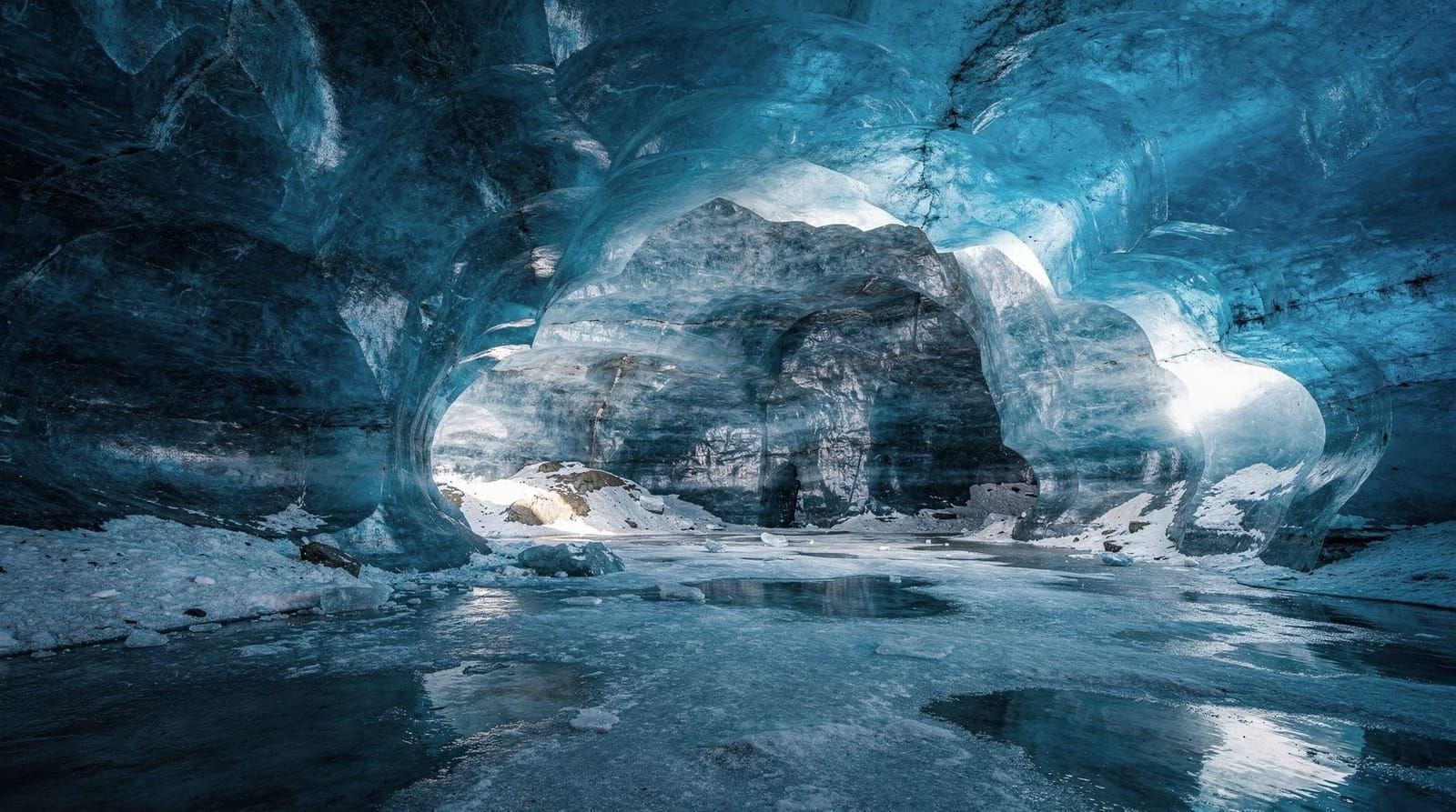
Katla ice cave (winter addition)
Katla volcano sits beneath Mýrdalsjökull and the glacier above it harbors natural ice caves accessible October through March. The cave interior exposes black ash layers from Katla’s last major eruption (1918) compressed between ice walls — geology you can touch. Access requires a super jeep to cross the lava fields and a guided trip from Vík or Reykjavik.
Book a Katla ice cave and South Coast day tour from Reykjavik if visiting between October and March. The caves are accessible only with approved guides — going independently is not permitted.
Guided tours versus self-drive
The South Coast is entirely on paved Route 1 — a basic rental car handles it in any season (with winter tires in snow conditions). Self-drive lets you spend longer at Seljalandsfoss before crowds arrive and avoid the rushed pacing of bus tours.
Guided tours add value primarily for: first-timers who want context explained, glacier hiking (guide required on the glacier), and ice cave visits (guide required). A standard full-day South Coast tour from Reykjavik costs 15,000-25,000 ISK depending on group size and whether glacier hiking is included. A small group South Coast tour with glacier hike represents good value compared to booking them separately.
See the full South Coast complete guide for seasonal conditions and an honest schedule for one versus two days. For a complete 5-day plan from Reykjavik, the Iceland summer 5-day itinerary incorporates the South Coast with overnight at Vík.
Top experiences
Bookable activities with verified prices and instant confirmation on GetYourGuide.