Snæfellsnes Peninsula: glacier, lava caves, and Kirkjufell
How to visit Snæfellsnes in a day from Reykjavik: Kirkjufell, Snæfellsjökull glacier, Vatnshellir lava cave, Djúpalónssandur. Drive times and costs.
Reykjavik: Snaefellsnes Peninsula and Kirkjufell Day Trip
Quick facts
- Distance from Reykjavik
- ~180 km to Kirkjufell, ~2-2.5h
- Drive around full peninsula
- ~200 km loop from Borgarnes, ~5-6h with stops
- Vatnshellir lava cave entry
- ~3,500 ISK (~€24) guided
- Snæfellsjökull glacier hike
- Guide required; ~15,000-22,000 ISK
- Djúpalónssandur
- Free, off Route 574
Iceland’s western peninsula: everything the Golden Circle has, minus the crowds
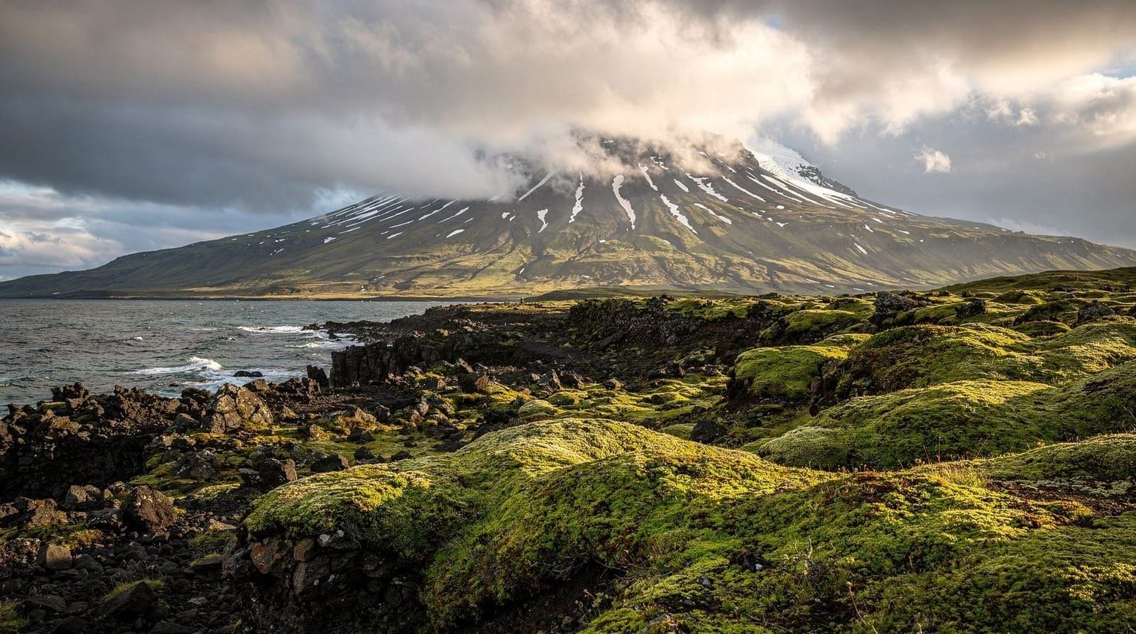
The Snæfellsnes Peninsula extends 90 km westward into the Atlantic from the Snæfellsbær region, terminating in the Snæfellsjökull glacier that Jules Verne used as the entrance to the center of the earth in his 1864 novel. It is geologically varied — lava fields, sea cliffs, fishing villages, a glacier volcano, and black pebble beaches — and consistently less crowded than the Golden Circle despite offering comparable landscape diversity.
The drive from Reykjavik to Kirkjufell takes approximately 2-2.5 hours via Route 1 north and Route 54. A full loop of the peninsula adds another 3-4 hours of driving and stops. One long summer day handles this; in winter the short daylight hours (3-5 hours in December) make a focused itinerary essential.
| Where | ~180 km northwest of Reykjavik, western Iceland |
| Time needed | Full day for the loop; a night in Stykkishólmur for a relaxed two |
| Cost | Free to view; guided extras 3,500-22,000 ISK |
| Getting there | Self-drive on paved roads, or a guided day tour |
| Best time | May-October for full accessibility |
Reykjavik: Snaefellsnes Peninsula and Kirkjufell Day Trip
Snæfellsnes versus the Golden Circle
| Snæfellsnes | Golden Circle | |
|---|---|---|
| Distance from Reykjavik | ~180 km, 2-2.5h | ~50 km, 1.5-2h to first stop |
| Crowds | Noticeably quieter | Consistently busy, especially midday |
| Landscape variety | Glacier, sea cliffs, lava, fishing villages | Waterfalls, geysir, tectonic rift |
| Best for | Travelers who’ve done a Golden Circle-style loop before, or want quieter photography | First-time visitors wanting the classic three sites |
| Day-trip feasibility | Long day, tight in winter | Comfortable single day year-round |
Kirkjufell: Iceland’s most photographed mountain
Kirkjufell (463 m) stands as a near-perfectly conical isolated mountain rising from the north coast of the peninsula near the village of Grundarfjörður. It is the most recognizable silhouette in Iceland’s landscape photography — and gained additional global exposure from its appearance in Game of Thrones, where it appeared as the “Arrowhead Mountain” north of the Wall.
The standard composition frames Kirkjufell with Kirkjufellsfoss, the three-tiered waterfall in the foreground, visible from the road or a short gravel path. The waterfall is small but well-positioned for this shot. In winter (November through March), northern lights over Kirkjufell are a popular chase scenario; several operators run Snæfellsnes northern lights tours specifically targeting this backdrop.
The mountain itself requires a challenging scramble to summit — the path is technically demanding and should not be attempted in poor weather or by unprepared hikers. The view from the roadside is the standard experience.
Snæfellsjökull: the glacier at the end of the peninsula
Snæfellsjökull is a stratovolcano (last erupted ~1750) capped by a glacier of the same name, forming the terminus of the peninsula and the centerpiece of Snæfellsjökull National Park. The glacier surface is accessible by snowcat tours operated year-round by local providers (Snjófell, Hidden Iceland), but guided glacier hikes require specific operators with permits.
The Snæfellsjökull Visitor Center in Hellnar is the logical base for the national park. Several short hiking trails run across the lava fields below the glacier including Saxhóll (a short crater climb with a ladder to the rim) and Dritvík cove.
The National Park entry is free; the glacier summit tour costs approximately 15,000-22,000 ISK (~€102-150) per person.
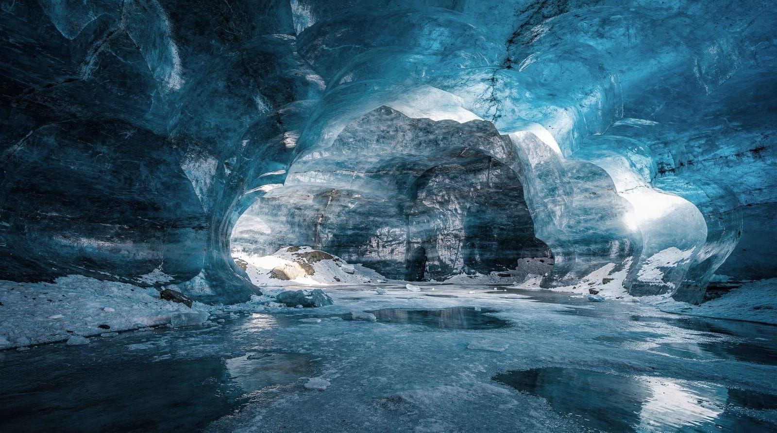
Vatnshellir lava cave
Vatnshellir is an 8,000-year-old lava tube, 200 meters long, descending about 35 meters below the lava field surface. Guided tours run year-round (hourly in summer, reduced schedule in winter) and include a hardhat, flashlight, and 45-minute guided descent.
Book the Vatnshellir lava cave tour on Snæfellsnes on arrival at the site — advance booking is usually possible but not always necessary outside peak summer weekends. Cost: approximately 3,500 ISK (~€24) per adult. The cave interior is genuinely dark; the experience of being inside a lava tube is distinct from anything above ground in Iceland.
Djúpalónssandur: the black pebble beach
Unlike Reynisfjara’s fine black sand, Djúpalónssandur is a beach of black rounded volcanic pebbles and boulders. At the entry to the beach stand the “Lifting Stones” — four stones of different weights (23 kg, 54 kg, 100 kg, and 154 kg) used historically to test fishermen’s strength before crew selection. Scattered along the upper beach are rusted metal fragments from a British trawler (Epine) wrecked here in 1948.
The cove is sheltered by lava cliffs and feels isolated despite being on a signposted route. Free parking off Route 574, about 30 minutes from the Snæfellsjökull glacier access area.
Arnarstapi and Hellnar: the cliff walk
Arnarstapi and Hellnar are small fishing communities on the south coast of the peninsula separated by 2.5 km of dramatic sea cliff trail. The walk passes basalt arches, sea caves, and seabird colonies (fulmars, kittiwakes, common guillemots). The Arnarstapi harbor has a striking basalt arch at sea level.
Both villages have small restaurants serving soup and fish; Fjöruhúsið café at Hellnar is a local institution for coffee and waffles (open summer only, crowded on weekends). The cliff walk is easy, takes about 45-60 minutes one way, and is free.
Lóndrangar basalt cliffs
Lóndrangar are two basalt sea stacks rising 75 meters above the sea — the eroded vents of an ancient volcanic eruption. A short trail (15 minutes) leads to a viewpoint over the stacks. In summer, the cliffs host large seabird colonies. Free, off Route 574.
Bjarnarhöfn shark museum
Bjarnarhöfn, on the north coast near Stykkishólmur, is a working farm and the traditional home of hákarl — fermented Greenland shark, Iceland’s most notorious food export. The small on-site museum explains the multi-month fermentation and drying process and includes a tasting of the finished product, served with a shot of Brennivín schnapps to follow it. It is a genuinely informative stop for understanding a piece of Icelandic food culture that most visitors only encounter as a dare. Entry with tasting runs a modest fee, payable on-site.
Ólafsvík and Rif: the fishing villages
Ólafsvík and the smaller Rif sit on the peninsula’s north coast between Kirkjufell and Snæfellsjökull, working fishing harbors with none of the tourist infrastructure of Stykkishólmur. Ólafsvík has a small folk museum and a supermarket if you need supplies; Rif’s harbor gives an unpolished sense of the fishing economy that underpins this coastline. Neither requires more than a brief stop, but both are useful waypoints if you are timing the drive around Snæfellsjökull’s changeable weather.
Stykkishólmur
The largest town on the peninsula (population ~1,200), Stykkishólmur sits on the north coast and has a small harbor, the Norwegian House museum, and ferry connections to the Westfjords (the Baldur ferry). It is a logical overnight stop if you want to do the peninsula in a relaxed two days.
Eating in Stykkishólmur: Sjávarpakkhúsið restaurant at the harbor serves creditable fish at ~3,500-5,000 ISK per main. A 2-hour sea kayak from the harbor gives a different perspective on the island-dotted bay — book a sea kayak tour from Stykkishólmur if you want a water-level view of the volcanic rock formations.
Self-drive versus guided tour
The peninsula roads (Route 54 around the north, Route 574 along the south) are paved and accessible by standard rental car from May through October. Winter conditions require studded tires and caution on Route 574; the road to the glacier summit is often closed with snow.
The tour from Reykjavik makes sense if you do not have a car or if you want commentary on the geology and the Verne literary connections. Full-day guided options run 12-15 hours from Reykjavik and typically cover Kirkjufell, Djúpalónssandur, Arnarstapi, and the national park. A small-group Snæfellsnes day trip keeps the group size manageable and allows more time at each stop than the large-bus versions.
For a complete Snæfellsnes day-trip plan with timings, see the Snæfellsnes day trip guide. For the full 5-day itinerary incorporating the peninsula with the South Coast, see the Iceland 7-day itinerary from Reykjavik.
Top experiences
Bookable activities with verified prices and instant confirmation on GetYourGuide.